TravelTalkOnline

Tracking Irma and why I did not prepare

Posted By: sxmmartini

Tracking Irma and why I did not prepare - 08/22/2019 01:29 PM

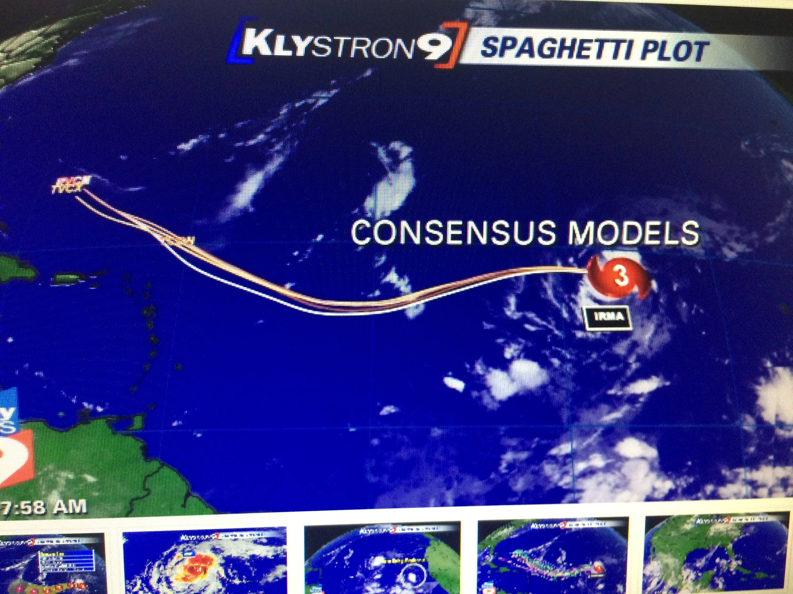
I wanted to post about why I did not prepare for Irma. I go to every weather site during hurricane season. I should know by now that computer models and experts are wrong most of the time. I have an old screen shot when Hurricane Irma was a Cat 3 and it showed every track going north of St. Maarten/ St. Martin. People forget that the true track caught everyone off guard including me. My point is just prepare and don't believe the computer models. Here is the track of Irma...

Attached picture image.jpeg
Posted By: Bluesfan

Re: Tracking Irma and why I did not prepare - 08/22/2019 02:16 PM

Irma shifted south over the last 3 days. Every day it got worse. Hurricanes usually shift north.
Posted By: kim

Re: Tracking Irma and why I did not prepare - 08/22/2019 02:34 PM

Yup! We had buttoned up our condo on 8/30. Realized I didn’t set up “contents insurance” on the new place!!! Total panic mode. Took care of that last minute and the rest is history. Then two days after Irma hit I fell of my horse and fractured my sacrum and some other bones in my back! September truly sucked!!!!!!
Posted By: BillandElaine

Re: Tracking Irma and why I did not prepare - 08/22/2019 02:44 PM

We prepare for the worst so we're not blindsided.
Posted By: Jim_Laraine

Re: Tracking Irma and why I did not prepare - 08/22/2019 03:01 PM

We were on the island for the month of August before Irma hit. I seem to remember 2 other storms came at us and veered north during our stay. We were watching Irma and figured it would do the same. We were very fortunate, our planned departure date had us leave a few days before the storm hit.
Posted By: mahokid

Re: Tracking Irma and why I did not prepare - 08/22/2019 07:20 PM

Moved from Orient down to Maho the week before Irma hit and stopped at Super U in Marigot.
When you see shopping carts filled with water and long lines down the aisle, you got to think something
is a bad possibility.
Not until about 3 days before did we really start to think about getting out.
We did have about a three-four days of just in case food.
We have been through a Cat 3 and they say Royal Islander can within a Cat 4 so we felt safe.
We got out on a miracle last minute seats that day which got booked the previous night.
I believe someone did not confirm their seats as all flights to anywhere were booked for the entire week,
In a couple weeks we will meet up with our friends who got all our food and stuck on the island for a week after Irma.
Posted By: sxmmartini

99L Invest - 08/23/2019 12:31 PM

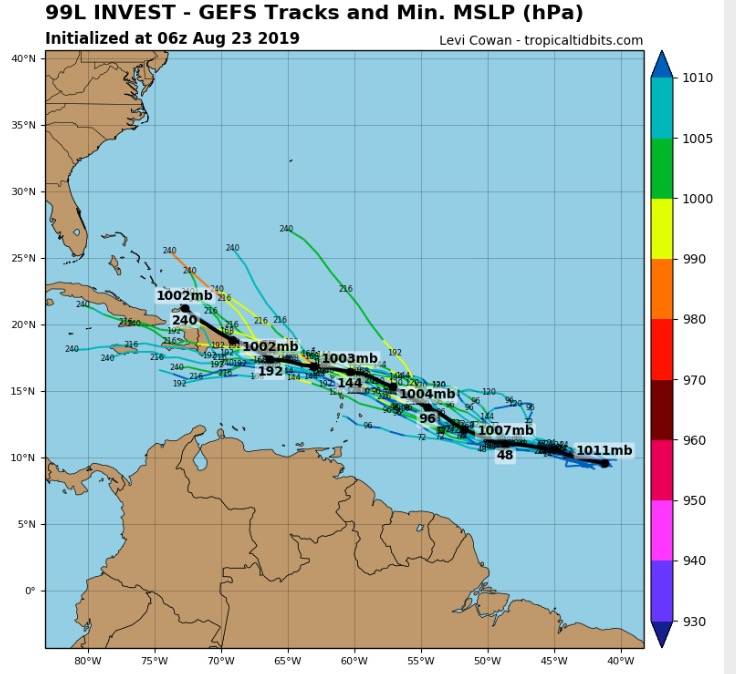
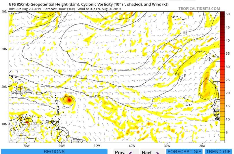
Here is one to watch... 99L Invest

Attached picture image.jpeg
Posted By: SammyM

Re: 99L Invest - 08/23/2019 01:47 PM

Yes, this one probably merits some watching. But, if those forecasted pressures are correct (1002 to 1007 millibars), this won't even be a Cat 1 hurricane but rather a tropical storm. Many people believe wind speed is the measure of a hurricane's strength, but it's really the barometric pressure that indicates true intensity. When Irma struck two years ago the pressure hit 914 mb as it moved onshore to St. Maarten. That's a crazy low pressure reading, only surpassed in my lifetime by Hurricane Camille which ravaged the Mississippi gulf coast 50 years ago with a 909 mb reading. So, I'll keep watching this 'area of suspicion' and hope it amounts to nothing.
Posted By: Leagle49

Re: 99L Invest - 08/24/2019 11:40 AM

Now that Crown Weather is a pay only site, is there a good free site to look at tropical weather?
Posted By: Bluesfan

Re: 99L Invest - 08/24/2019 02:52 PM

nhc.noaa.gov
Posted By: SXMScubaman

Re: 99L Invest - 08/24/2019 02:59 PM

Originally Posted by Leagle49
Now that Crown Weather is a pay only site, is there a good free site to look at tropical weather?

Is that the one Jeff Berger is always promoting on Facebook and his newsletters?
Posted By: BillandElaine

Re: 99L Invest - 08/24/2019 03:06 PM

Don't know, but it is the best site. I don't subscribe, but have friends that do and they post updates. Check Island92 FB page.

Although it's not expensive $10 a month so not bad if you do only 3 months it's worth the $ if you have interests in hurricane season.
Posted By: bran

Re: 99L Invest - 08/24/2019 05:37 PM

Originally Posted by Leagle49
Now that Crown Weather is a pay only site, is there a good free site to look at tropical weather?


Yes..........He will only post nightly when he knows there could be serious trouble coming and I cant even tell you how accurate this person was in 2017. He looks at all models but favors the European one that has proved to be more accurate over the recent years and the detail and videos he produces are just incredible. Book mark this everyone and you may be able to see previous posts of his to give you an idea....

www.tropicaltidbits.com
Posted By: SXMScubaman

Re: 99L Invest - 08/24/2019 06:18 PM

Thanks. Booked marked it.
Posted By: bran

Re: 99L Invest - 08/24/2019 07:20 PM

Forgot, also another brilliant one is stormcarib.com and tells you about each island and the people living there actually give live conditions as it happens.......look on right hand side for each Island.
Posted By: DavidC2065

Re: 99L Invest - 08/24/2019 08:49 PM

Mike's Weather Page on Facebook is excellent.
Posted By: BillandElaine

Re: 99L Invest - 08/24/2019 08:58 PM

Now Tropical Storm Dorian:

NOAA NWS National Hurricane Center
5 mins ·
...DEPRESSION STRENGTHENS INTO THE FOURTH TROPICAL STORM OF THE 2019 ATLANTIC HURRICANE SEASON...

NHC has upgraded Tropical Depression Five to Tropical Storm Dorian. It's centered as of 5 p.m. AST/EDT over the tropical Atlantic Ocean about 725 miles (1165 km) east-southeast of Barbados. There are no coastal watches or warnings in effect. Interests in the central and northern Lesser Antilles should monitor the progress of Dorian.

Dorian is moving toward the west near 12 mph (19 km/h). A turn toward the
west-northwest is forecast on Sunday, and that motion is expected to continue through Tuesday. On the forecast track, the tropical cyclone is expected to be near the central Lesser Antilles on Tuesday.

Maximum sustained winds have increased to near 40 mph (65 km/h) with higher gusts. Tropical-storm-force winds extend outward up to 25 miles (35 km) from the center. Gradual strengthening during the next few days is forecast, and Dorian could be near hurricane strength when it approaches the central Lesser Antilles on Tuesday.

Get the latest on Dorian at www.nhc.noaa.gov/#Dorian
© 2024 TravelTalkOnline