|
Forums39
Topics40,699
Posts330,026
Members26,933
| |
Most Online4,031
Dec 15th, 2024
|
|
|
Posts: 2,262
Joined: July 2011
|
|
|
0 members (),
625
guests, and
63
robots. |
|
Key:
Admin,
Global Mod,
Mod
|
|

#42223
02/25/2015 07:30 PM
|
Joined: Oct 2000
Posts: 287
Traveler
|
OP

Traveler
Joined: Oct 2000
Posts: 287 |
when driving fom the airport to pburg or vis-versus we take brouwers road over the hill. However, in looking at the map it looks like there is a shortcut taking arlet peters road, maybe one way. Anyone know anything about this route
|
|
|
 . .
|
|
|
|
Joined: Dec 2008
Posts: 2,117 Likes: 1
Traveler
|
|
Traveler
Joined: Dec 2008
Posts: 2,117 Likes: 1 |
Arlet Peters Road is a one way road coming from Philipsburg to Cole Bay. It is also very steep and curvy.
Fair winds and following seas!
SSN691-May She Ever Prowl The Seas in Defense of Human Freedom!
SSN787-Preserving Peace, Prepared for War
|
|
|
|
|
Joined: Dec 2008
Posts: 2,117 Likes: 1
Traveler
|
|
Traveler
Joined: Dec 2008
Posts: 2,117 Likes: 1 |
Here is a link to an on-line map that you can click and drag or zoom in and out: http://www.mapsxm.com/
Fair winds and following seas!
SSN691-May She Ever Prowl The Seas in Defense of Human Freedom!
SSN787-Preserving Peace, Prepared for War
|
|
|
|
|
Joined: Dec 2007
Posts: 464
Traveler
|
|
Traveler
Joined: Dec 2007
Posts: 464 |
tried it a couple of years ago. It is very steep and curvy. You must trust your rental car brakes. My Wife refuses to ever use it again. Many of the locals use it, but they are driving their own vehicles and are aware of mechanical condition.
|
|
|
|
|
Joined: Sep 2001
Posts: 888
Sponsor
|
|
Sponsor
Joined: Sep 2001
Posts: 888 |
That's the Cakehouse shortcut. So named because it starts in Pburg at the Cakehouse Bakery. Or at least it did when the road was built. The bakery moved shortly thereafter. It really makes the trip from Pburg to Unity Road in Cole Bay much shorter. Whenever we shop in Pburg we use it to return home to Cupecoy, especially if we want to stop at Select Wine or the Grand Marche. I believe it is shorter for us to use the shortcut and proceed to the causeway than it is to go on the normal road to the Kruythoff rotary and over the bridge to Simpson Bay.
|
|
|
|
|
Joined: Oct 2000
Posts: 287
Traveler
|
|
OP
Traveler
Joined: Oct 2000
Posts: 287 |
Thanks for the info - do taxi's us it as a shortcut to avoid traffic?
|
|
|
|
|
Joined: May 2003
Posts: 1,303
Traveler
|
|
Traveler
Joined: May 2003
Posts: 1,303 |
I've used that road several times to get to Port de Plaisance from P'burg and always in the daytime. Last year we (or should I say "I") decided to take it at night!! Never again - it was very scary and if you get someone following very closely behind you who most likely knows the curves well - it was definitely a white knuckle experience. I thought my husband was going to kill me once he realized we arrived back safely. after a few what the hell is wrong with you - are you crazy?? I realized he was right!! <img src="http://www.traveltalkonline.com/forums/images/graemlins/jester.gif" alt="" />
|
|
|
|
|
Joined: Aug 2000
Posts: 85,067 Likes: 59
Traveler
|
|
Traveler
Joined: Aug 2000
Posts: 85,067 Likes: 59 |
I have no problem with that road in the daytime. At night?? No freaking way!! <img src="http://www.traveltalkonline.com/forums/images/graemlins/Laugh.gif" alt="" />
Carol Hill
|
|
|
|
|
Joined: Jul 2001
Posts: 7,132
Traveler
|
|
Traveler
Joined: Jul 2001
Posts: 7,132 |
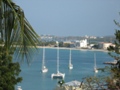
Been using Cake House Road for years as a cut thru to Cole Bay. Some incredible views of Simpson Bay area from top.
Next SXM visit -November 2023. Also January 2024.
|
|
|
|
|
Joined: Oct 2011
Posts: 813 Likes: 6
Traveler
|
|
Traveler
Joined: Oct 2011
Posts: 813 Likes: 6 |
SXMNorm said:
Been using Cake House Road for years as a cut thru to Cole Bay. Some incredible views of Simpson Bay area from top. I actually LOVE that road. We call it "up and over".
|
|
|
|
|
Joined: Nov 2006
Posts: 39
Traveler
|
|
Traveler
Joined: Nov 2006
Posts: 39 |
always wanted to take that road
|
|
|
|
|
Joined: Oct 2013
Posts: 368
Traveler
|
|
Traveler
Joined: Oct 2013
Posts: 368 |
Who says its steep???????? Steep does not define it!!!!!Use low gear and pump the brakes. Nice view.
|
|
|
|
|
Joined: Nov 2009
Posts: 3,279
Traveler
|
|
Traveler
Joined: Nov 2009
Posts: 3,279 |
We always laugh when we take that route and joke that "it must be really scary when it's icy".... <img src="http://www.traveltalkonline.com/forums/images/graemlins/jester.gif" alt="" />
"It is good to do nothing all day, and then to rest" 
|
|
|
|
|
Joined: Sep 2004
Posts: 879
Traveler
|
|
Traveler
Joined: Sep 2004
Posts: 879 |
lcote said:SXMNorm said:
Been using Cake House Road for years as a cut thru to Cole Bay. Some incredible views of Simpson Bay area from top. I actually LOVE that road. We call it "up and over". I believe some psychologists categorize that as a death wish.
|
|
|
|
|
Joined: Jan 2002
Posts: 708 Likes: 5
Traveler
|
|
Traveler
Joined: Jan 2002
Posts: 708 Likes: 5 |
BeachKitten said:
We always laugh when we take that route and joke that "it must be really scary when it's icy".... <img src="http://www.traveltalkonline.com/forums/images/graemlins/jester.gif" alt="" /> ok you stole my joke! I have been using that line for years
|
|
|
|
|
 .
.